Thursday, 25 July 2019


17 July

Macona Inlet to Border Island

Another lovely day today. For interest (and a bit of fun), we're leaving the VHF radio radio switched on and scanning the bareboat communication channels.  We've heard one boat advise that they're coming home early, citing "disagreements amongst the crew", and another boat asking how to switch from one fresh water tank to the other.  When the charter base expressed concern that they'd used half their water on only their second day out, they noted "we've had a meeting with the girls about water use".

We've settled into a pretty easy routine, with slow breakfasts and departures around mid morning for short sails of an hour or two between anchorages.  I launched the drone this morning.  The footage I took didn't inspire me to edit it into a self contained video, but it will contribute to something in future.  At the least it did get me a very nice still image of part of the inlet.


Macona Inlet and our anchorage.  The fringing reef is quite evident as a darker patch.

I had the sails up almost immediately after exiting Macona Inlet and, as a first for me, I left them up through the narrow channel between Hook and Whitsunday Islands (Hook Passage). From there it was a glorious though short reach across to Cataran Bay on Border Island.  There are moorings available here, but they have a two hour time limit and not all are rated for our boat length.  It seemed far less hassle just to use our anchor in about 13-15 meters of water, so that's what we did.


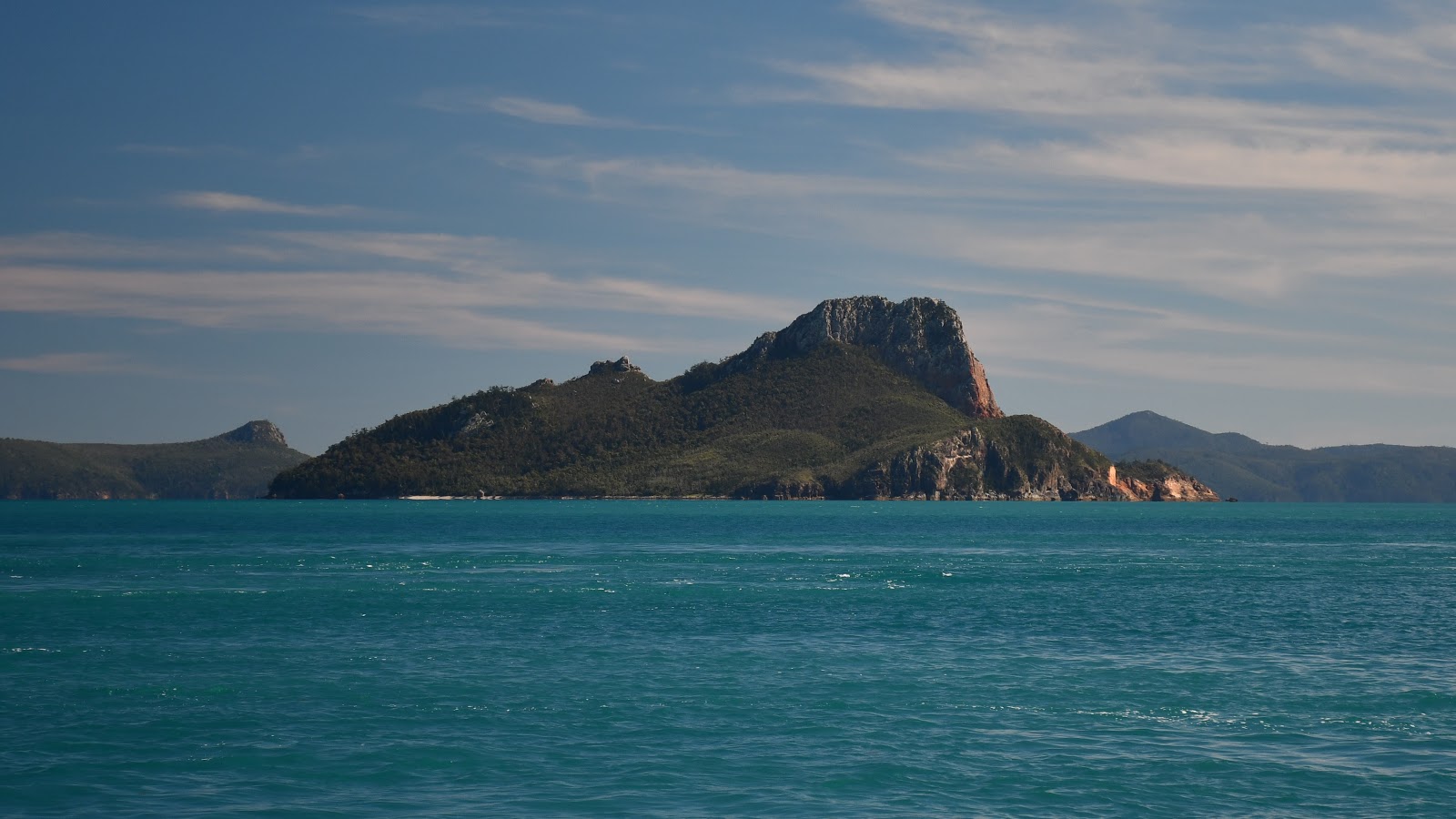
A really enjoyable sail across to Border

David joined in the fun

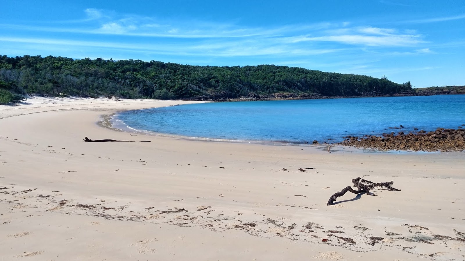
The small beach in Cataran Bay

Once the engine was off we realised we had a problem somewhere in the domestic fresh water system.  Turns out that a stop valve on the stern shower hot water hose had broken and hot water was gushing into the stern locker.  This could have been more serious if I'd been accessing water from one of our larger tanks, because of the loss of water that would have occurred.  As it was we were still taking water from one of the small 50 litre bladders and the loss was minimal. I found a replacement part from my stock of spares (lucky!) and David and I managed to get the whole thing replumbed within an hour.  These are the little things that we have to deal with when we're doing a long cruise.  Hopefully we won't have any big things go wrong.

David taking a turn battling with a broken water hose


16 July

Cid Harbour to Macona Inlet

A short hop today from Cid Harbour to Macona Inlet on Hook Island.  On the way out of the enchorage Anne spotted a pair of dugongs swimming under the boat.  Appropriate, since we’re leaving Dugong Bay.  I think if it was anyone else making the sighting I might have been a little sceptical, but Anne is a research biologist by training so I think the sighting is pretty reliable.

Boats lit up last night in Cid Harbour
Mix'd Nutz, Kailani and Galadriel closest

The prevailing wind is still a pretty strong 20+ knots with more south in it than normal, keeping a lid on the temperatures.  The rest of the fleet head south after breakfast, aiming for Hammo in two days’ time.  We go north, along with the wind and the current, and have a much happier time of the conditions.  

In all the trips I’ve made here I’ve never gone into Macona, always favouring its more popular next door neighbour, Nara Inlet.  Both are long, deep flooded valleys with high sides and narrow entrances.  Macona turns out to be lovely and shames me regarding my previous inattention.  It has an extensive fringing coral reef, with a significant indentation in the coral where anchoring is possible almost as if it were a lagoon, albeit open on one side. 

Anne spotted what appears to be a small family of dolphins in the bay, feeding and playing.  Being a biologist, she recognised that they’re not the bottlenose dolphins we normally see and identifies them from the internet as being humpback dolphins, listed by the Queensland government as being a vulnerable species.  Combined with the dugongs earlier on, that's enough to make her day.


A small beach just off our stern

Looking out through the entrance to Macona Inlet, and at dusk...


Moon rise


Wednesday, 24 July 2019


15 July

Cid Harbour

Cid Harbour has a lot going for it.  On top of being a very large and extremely well protected anchorage, it is really quite beautiful.  It's also the starting point for a walk up to the highest point in the entire island group – Whitsunday Peak on Whitsunday Island, at a height of 437 meters.  The other crews did this walk yesterday and David and I will tackle it today, the first time for both of us.  Anne will stay aboard and bake fresh scones, which we don’t object to in any way.

While I’m mentioning Whitsunday Island, it’s worth noting a little piece of historical detail.  Cook sailed HM Bark Endeavour through this area on Whitsunday in 1770.  He named only one island – Pentecost Island - but he named the entire island chain (extending from the present day Mackay to north of Hayman Island) the Cumberland Isles after the Duke of Cumberland, brother to King George III.  He also named the Whitsunday Passage through which he sailed on that day, bound on one side by what we now know as Whitsunday and Hook Islands and on the other by the mainland.  All the other islands were named during the 19th century.  Modern references to “the Whitsundays” are more recent and I suspect are as much a product of tourism marketers as anything else.  I still like the sound of “the Whitsunday Passage” because of the romantic notions it conjures up in my mind, although it doesn’t get much mention anymore.  I heard it referred to many times when I was very young.  Back then it took on quite a magical connotation, years before I had any real understanding of what it was really like, but it still retains that same sense to me now.

But back to today and the walk to Whitsunday Peak.  I was surprised at how easy the walk proved to be.  To be sure, it was a consistent upwards hike with only a few stretches of level walking.  But the incline was steady without being gruelling.  We covered the distance from the beach to the peak in a little over an hour.  It truly is the roof of the Whitsundays and the views were magnificent.  The northern side of the Peak remained warm and sunny, being protected from the still strong, and cold, southerly wind.  The southern side was sunny, cold and very windy.

The name is a reminder of the timber industry that once existed here

Part of the response to three shark attacks in Cid Harbour last year, including the sad death of a bareboater

David crossing the creek on a lower section of the track

Me, climbing some of the many steps on the way up, kitted out with camera and handheld VHF

Me again, and an example of this very well maintained track

The Whitsunday Passage from its roof - an awe inspiring sight

Cid Harbour in the foreground, with part of Sawmill Beach showing to the left
Hook Island is furthest away

The two of us

Looking south, with Gulnare Inlet immediately below and Hammo resort very distinct

Obviously I have a thing for Pentecost Island

This is the sort of place where you want to just sit and soak up the experience.

The descent was relatively quick.  For good measure we tackled another short walk once we reached the bottom, around to the beach in the adjoining bay.  I remember having done that walk back in the 1980s.  At that time there was a lovely palm grotto along the track.  That grotto has now grown up and is much thicker with vegetation.  Like all the other bush we’ve seen so far, the extensive damage from Cyclone Debbie is plain to see.  Huge trees have simply been snapped mid trunk, or ripped out of the ground.  National Parks staff have done a remarkable clean up by cutting fallen trees to keep the tracks accessible.


Dugong Beach is the other main beach in Cid Harbour


Tuesday, 23 July 2019


14th July

Hamilton Island to Cid Harbour

Hammo gave us a great evening last night.  As forecast, the wind blew and continued to blow through to this morning.  Our marina reservation was good through to 11am, but the prospect of even getting out of the pen in the prevailing 25-30 knot winds didn't really appeal.  I expected them to drop by early afternoon, so the best thing is to extend our stay by a few hours and have a relaxed morning around the island.

Gypsy Princess in the Hammo marina

Harbourside on Hamilton Island - golf buggies replace cars on the island

I have three things in mind – (1) visit the big new IGA store to top up our perishable food supplies, (2) catch the shuttle bus up to the top of One Tree Hill for some sightseeing and (3) most importantly, get myself another mango smoothie.  The shuttle bus also gave us a tour of the island, including the areas around the staff quarters.  Some of these are absolutely tiny.  I hope there are staff R&R facilities available because you’d go crazy if all you had was a bed and somewhere to stand up in.

A panorama from the top of One Tree Hill by Anne
To the left is Whitsunday Is, to the right is the resort

David (holding my smoothie) and Anne, with the Whitsunday Passage extending northwards

Davis and Anne showing off the passage we'd come through in lighter winds yesterday

Another shot of the Whitsunday Passage

Catseye Bay and part of Hamilton Island resort


By around 1pm the wind inside the harbour had come down to a gentle breeze and exiting the marina pen became simple.  Our overnight destination was Cid Harbour, where the rest of the Club boats were holed up.  We had a brisk wind behind us, at around 20 knots, for the short trip.  Cid Harbour is one of the best natural anchorages in the entire area and, once inside its shelter, it was a virtual calm.  We made it in time for afternoon tea (ie, no alcohol!) on Galadriel.

Me, at the wheel, as we leave the marina

Dusk at anchor in Cid Harbour


13 July

Whitehaven Beach to Hamilton Island

I remember the days when I first started coming here, when I’d take the yachts’ dinghies for rows every morning.  In those days the dinghies were good old-fashioned tinnies – heavy but solid rowers.  I’ve previously only owned flimsy dinghies that defied being rowed.  However my new dinghy is a RIB, aluminium hull with inflated pontoons around its sides.  It rows just fine and early this morning I took it rowing three quarters of a mile, down to the very end of the beach.  Yet another way to indulge in the old pleasures.

On a different note, I’m having trouble with photographic equipment.  My new camera seems to react harshly to its polarising filter, producing photos with excessive contrast, overly vibrant colours and being apparently underexposed.  I’m having to learn how to correct for all of those issues by manipulating the Raw image files it’s saving with each photo.  Judge for yourself how I’m doing.  I think the longer term solution will be to adjust the camera settings.  I also put the drone up for a flight this morning.  After three seconds of filming it asked if I wanted to switch over to using its internal memory rather than its now full memory card, but it stopped filming anyway and my 10 minute flight up and down Whitehaven ended up producing nothing.  Well, there are too many boats and people here to do justice to the location anyway, and I’ll be back several more times this cruise.  Lots of opportunities to get some good flying in.

One thing I notice here is the devastation that’s been caused to the island by Cyclone Debbie back in March 2017.  It’s as if entire swathes of trees have been clear felled all along the beach and well back into the fringing bush, and then been piled up by some massive earth moving machine.  I know the beach itself was badly affected but my memory of it isn’t precise enough to tell how much sand remains missing.  New growth is returning but it’s going to take many more years before it returns to its former self.  Amazingly, the southern end of the beach looks almost untouched, and this is where we head for the day’s bushwalk.


Whitehaven gets its own special sign, down at its apparently lightly damaged southern end

Looking northwards along the beach

Looking back out from just inside the line of bush

David and Anne ready for our bushwalk
One of the locals - I saw some overseas visitors putting their fingers very close to this guy's mouth

The walk we do is relatively short, about 45 minutes each way to the beach at Chance Bay plus a short side trip up to a rock lookout.  A very nice stroll.


David and Anne at a lookout facing southwards

Closeup of Pentecost Island 

Chance Bay at the end of the walk


The BoM is predicting winds of up to 30 knots for tonight and into tomorrow.  The rest of the fleet is heading to Cid Harbour to ride it out, which is an excellent anchorage.  We’ve decided to break away and go into Hamilton Island’s marina since we wanted to spend a night there at some stage anyway.  The forecast seems to make tonight a good opportunity.  It’s not far around to Hammo, so we make it there in time to have a quick walk around the marina and resort. 

My primary objective is to buy a mango smoothie from the excellent ice creamery on the harboursie.  By the end of the day my phone told me I’d walked a total of 13km, made up of the bushwalk from Whitehaven and general sightseeing around Hammo.  Combined with my rowing earlier in the day this has probably been my most active day of the trip.

We saw a number of these wallabies on Hamilton Island

Dinner tonight is booked at Romano’s restaurant, which I’ve never previously been able to get into (lack of sufficient planning on my or anyone else’s part!), preceded by cocktails at the Hammo Yacht Club.


12 July

Shaw Island to Whitehaven Beach (Whitsunday Island)

There is probably no place on the entire Queensland coast as iconic as Whitehaven Beach.  It appears on holiday brochures, billboards and TV advertisements as one of the biggest drawcards of the entire state.  To be fair, this attention is deserved.  Its magic comes from a combination of its perfect white sand, its considerable length and gently curving shape, the spectacle of other islands dotted about in the distance and the tall peaks of Whitsunday Island towering over it all.  And the brilliant sparkling turquoise water everywhere.  This is where we’re headed today.

It would have been fun to have landed at Lindeman Island on the way, to check out another of Queensland’s abandoned island holiday resorts.  However we don’t really want to spend the time and Lindeman doesn’t present us with that great an anchorage anyway, so we simply motor past it and take some photos.

The Lindeman Island resort - closed but looking in rather good condition from this distance
Approaching the southern end of Whitsunday Island - Pentecost Island coming up on our port side

Pentecost Island - majestic

Our first stop is Chalkies Beach for a bit of snorkelling.  This proves to be disappointing in relation to the coral but still provided a good swim.  We headed over to our overnight anchorage at Whitehaven Beach where the rest of the cruising fleet were anchored after they’d spent last night at Thomas Island.  Unfortunately, the Riviera convention has also moved up to Whitehaven and, combined with day trippers ferried in from Airlie Beach and Hamilton Island, it’s busy both ashore and on the water.  Well, it’s a long beach and we can simply move away from the crowds.

Whitehaven Beach seen from our luncheon anchorage at Chalkies


11 July

Brampton Island to Shaw Island (via Thomas Island)

The rest of the cruising fleet remain one step ahead of us but we plan on catching up with them tonight at Thomas Island.  Thomas was the southern-most island that David and I reached on our very first bareboat sailing holiday in 1986, so this represents quite some milestone for me – I’m returning to the Whitsunday Passage on my own boat as I promised myself those 33 years ago.  The weather has pretty much returned to perfection, giving us a very pleasant 20 mile sail.    

As opposed to the leg between Bundaberg and Mackay, where islands were fairly sparsely scattered, we’re now entering a region where anchorages are only a few miles apart.  This completely changes the complexion of the cruising.  Not only are each day’s legs so much shorter and quicker, but we’re now spoilt for choice as to which island and anchorage to head to.  Of course this is what makes the islands of the Whitsunday Passage so wonderful for visiting sailors and holiday makers.  Not to mention their outstanding beauty and great weather.


Anne with view back to Brampton Island

Trolling for fish - no luck since the first day out of Bundaberg, now weeks ago


David and Goldsmith Island

The islands of the Whitsunday Passage, seen from my bow - no longer somewhere over the horizon

Sometimes all these benefits work against you.  Like today, when we turned into the intimate northern anchorage of Thomas Island, replete with several gorgeous gems of beaches, to discover a Riviera regatta was ensconced there.  We counted 18 of these motor cruises crammed into our anchorage, most in the 45-60 foot range.  Being devotees of Power, their dinghies were also overpowered macho symbols and were zipping around between the boats and the beaches, some for no other apparent reason than to burn petrol.

I confess to feeling quite disappointed that my return to the Whitsunday islands was tarnished by this mess.  The solution?  We picked our anchor up and motored the 45 minutes to Shaw Island where we found a quiet and very pretty place (though not as pretty as Thomas) to spend the night.  Not to worry, I’ll be back to Thomas soon enough.

Evening at anchor at Shaw Island